 During a renovation project, the structure of the building previously known as the David Farquhar Mann House was discovered to be half-timbered, a form of architecture generally attributed to the American Colonial style. The American Colonial style was popular from circa 1700 to circa 1780. Half-timbered structures employed framing using hand-hewn or sawn wood timbers with the spaces between the timbers being infilled with brick or wattle and daub. The exterior of half-timbered structures were seldom left uncovered. During construction, the exterior walls would have been covered with lap or similar wood siding. In American House Styles it is stated: "The half-timbered houses of early New England were covered with a beveled siding of wooden clapboards." [John Milnes Baker, American House Styles, W.W. Norton & Company, New York, NY, 1994, p 22.] The Encyclopedia Britannica notes that: "English inhabitants of the American colonies found it expedient to use an insulating layer of wood siding (clapboards or weatherboarding), and half-timbering was not visible from outside." [Website, Encyclopedia Britannica, at the url address: https://www.britannica.com/technology/half-timber-work.] Anyone, not aware of how the structure was originally constructed, upon seeing such a building, would assume that it was simply a wood frame structure. Although it is nostalgic to see exposed logs and chinking of a log house, even log structures were often covered with clapboard siding. [Douglass C. Reed, Log Cabin Mythology, Preservation Associates, Hagerstown, MD, 1978, p 7.] The siding protected the structural elements from the destructive aspects of weather and insects. One benefit of building in the half-timbered method was to keep the thickness ~ and therefore the overall weight ~ of the walls to a minimum. It should be noted that the walls of stone structures tended to be nearly a foot thick. The walls of log structures would tend to be between eight and ten inches thick. Brick structures, constructed in the Flemish Bond or American Bond manner would be between eight and twelve inches thick. A half-timber building's walls would be a mere four to six inches thick. Even a wall that thin, constructed in the half-timbered method was not relegated to a single floor but could support a second floor. Another benefit of half-timbering was the reduced number of bricks required. Eighteenth and early Nineteenth Century brick structures were not wood constructions covered with a single thickness veneer of brick as modern ones are. The walls of a totally brick building consisted of the exterior brick layer, the interior brick layer, and a layer of air between. The various bricklaying methods, including Flemish Bond, American Bond, etc., determined how the three layers were interconnected. While the exterior surface could be left as it was, the interior surface would need to be plastered. Brick structures required a large number of bricks and mortar. In the case of a half-timbered structure, there was only one layer of bricks filling the spaces between the wood timbers. A layer of wood siding covered the exterior and a layer of plaster covered the interior. The reduced number of bricks required was a very important one in a time when bricks for a building project often required fabrication by the builder, on site and at the time of the construction. There were few brick factories in operation, especially on the frontier in the earliest days of civilization. Although it is nostalgic to see exposed logs and chinking of a log house, even log structures were often covered with clapboard siding. The siding protected the structural elements from the destructive aspects of weather and insects. Identification of a half-timber structure, with its exterior walls covered with wood siding, would have been very difficult simply from its external appearance only. For that reason, the building previously known as the David F. Mann House has escaped serious scrutiny and study for its entire lifetime until now. In fact, when the extremely detailed Sanborn Fire Insurance Company maps were fabricated for Bedford Borough, the structure was represented in yellow, indicating it had been identified as a wood frame structure. The image below is from Plate 3 of the 1885 map.
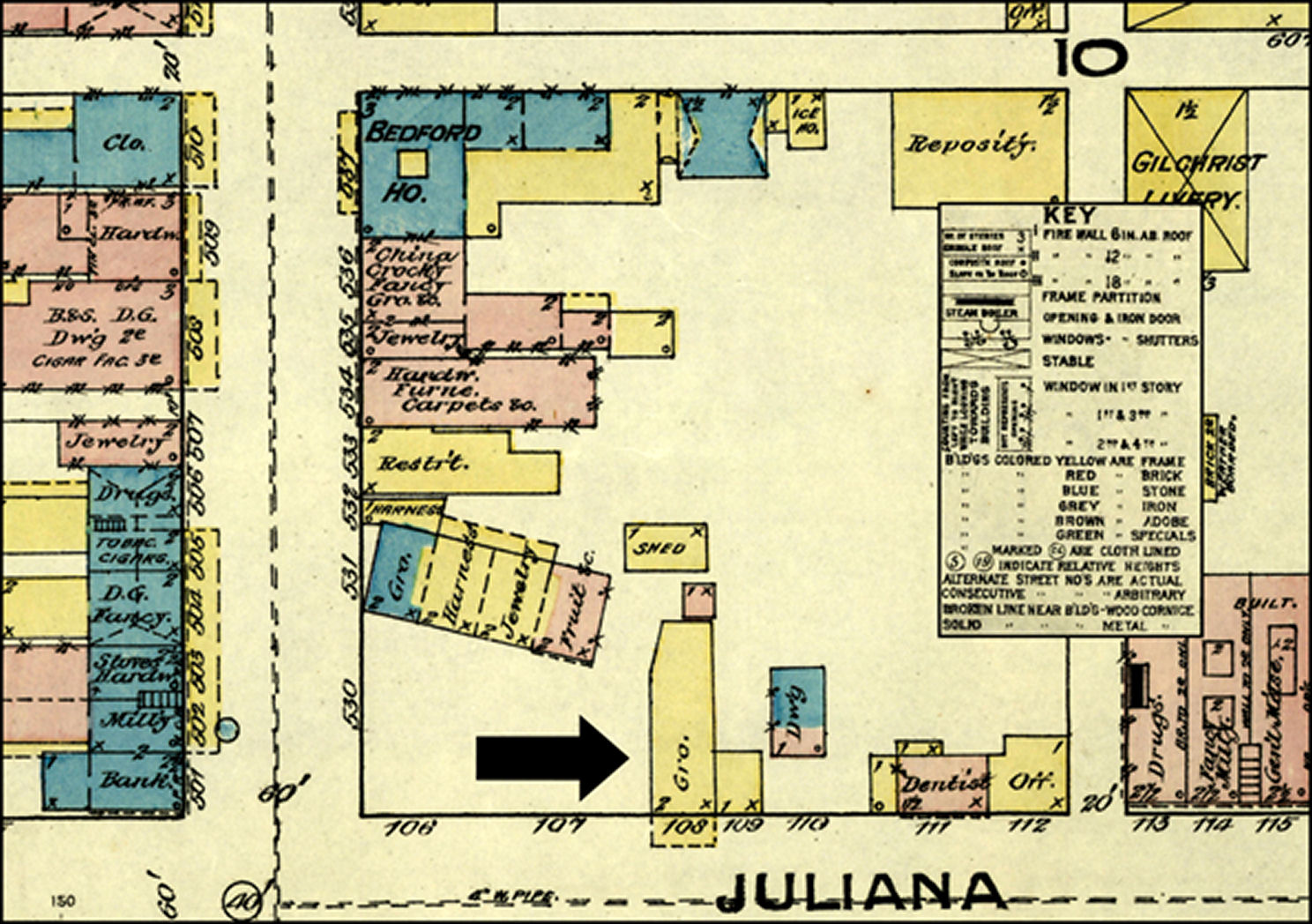
When the Forbes Expedition to take Fort Duquesne from the French in the summer of 1758 came through this region, the only Euro~American structures already standing in the vicinity would have been John Ray's trading post and Garrett Pendergrass' trading post. John Ray's trading post was probably located where the Dunning Creek empties into the Raystown Branch of the Juniata River, just west of the Narrows. Raestown was never a village as we assume by the name 'town.' In the 1700s, the word 'town' was derived from the Old English word, tun, which meant a walled or fenced place, which in turn had been derived from the German, zaun, meaning, literally, 'a fence.' The various trading posts scattered throughout the province, which, like Raystown, had the name of 'town' appended to their names (including Shanopin's Town, Frankstown, Cresap's Town, etc.), may have been so named because they likewise were comprised of groups of buildings surrounded by a fence or wall. Garrett Pendergrass' trading post was located in the vicinity of where the present-day Mountain Valley Apartments stand along the Raystown Branch of the Juniata River, a couple hundred feet to the east of Richard Street. In view of the fact that Pendergrass' trading post never achieved the name 'Pendergrasstown' it might be assumed that people who had firsthand knowledge of it knew that it consisted of a single structure. When Colonel Henry Bouquet brought General John Forbes' army into this region of south-central Pennsylvania in the summer of 1758, there was only one pre-existing resident in the vicinity. Despite the name of the trading post being used prominently for the immediate vicinity and various other natural features in the region, Bouquet made no mention of John Ray. Ray, who presumably had come into the region as early as the 1740s may not have still been here in 1758. On the other hand, Garrett Pendergrass was still in the region. His trading post was noted on a plan of the fort at Raystown attributed to J. C. Pleydell, but known as the Hulbert map. [Untitled and anonymous manuscript map of Fort Bedford reproduced in Hulbert (1907).] The plan is believed to have been made in 1759. Pendergrass continued to stay in the region until at least 1766 when he petitioned the Pennsylvania Assembly for recompense for the British Army's use of his land during the Forbes Expedition and the subsequent Pontiac's Rebellion. No other resident was noted to be in the vicinity in any of the extensive writings of Colonel Bouquet. And more importantly to determining a date for the construction of the Mann house, no structure, other than Pendergrass' was noted on any map or plan of the region. On 28 June 1758, Henry Bouquet wrote to John Forbes to inform his superior of his progress in getting a fortification built in the vicinity of the John Ray trading post. He stated: "Sir, I arrived here the 24th with the Pennsylvania regiment and the detachment of Virginia troops. I received your letter of the 19th on the 25th of this month, and as I had only the same express to send you, I have kept him until the present time so that I could give you an account of the establishment of this post. The road beyond Juniatta is very good, and all the woods are full of excellent forage. Since my arrival I have been almost constantly on horseback, searching with Captain Gordon for a terrain suitable for the proposed plan. We have searched without avail, and have found only high ground without water, or water in low and vulnerable places. Of the two inconveniences we finally chose the least and decided on the location which seemed least objectionable. The fort intended to contain our stores will be on a height, and will have a communication with a water supply which cannot be cut off. Work was begun this morning, and will be pushed with all possible dispatch.' [S.K. Stevens, Donald H. Kent, Autumn L. Leonard (eds), The Papers of Henry Bouquet, Volume II, The Pennsylvania Historical and Museum Commission, Harrisburg, 1951, pp 142-144.]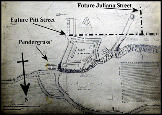
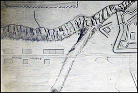
Other than Pendergrass' trading post, one other structure apparently stood on the 'height' as Bouquet called it, prior to the arrival of the British Army. But by the time the army arrived, it was no longer standing. William Fredregill, in the year 1755, established a homestead a short distance to the west of Garrett Pendergrass' property. A number of books mention Fredregill as having been a 'trader', but do not offer much additional information. A Memorial submitted by John Ormsby to the Governor of Pennsylvania, dated 24 February 1772 stated: "That a certain William Fredregill in the year of our Lord 1755 in Consequence of the Encouragement given to people to settle on the vacant Lands on the Western Frontiers of the said Province did settle on a certain Tract of Land near Raystown now called Bedford then vacant, which Tract of Land the said Fredregill occupied, built a dwelling House thereon, and made several other Improvements and continued in possession untill he was driven off by the Indians in 1757, and his House and other Buildings were by them burnt and destroyed. That some years after the said Tract of Land and Improvements were included in the Survey of a Manor laid out for the Honourable the Proprietaries." [Waterman, Watkins & Co., History of Bedford, Somerset and Fulton Counties, Pennsylvania, Waterman, Watkins & Co., Chicago, 1884, p 243.] The Fredrigill property would have been located along the north side of present-day Pitt Street and east of present-day Thomas Street. As noted in Ormsby's Memorial, any structure that existed there at one time had been burned. No structures occupied the high ground on which Bouquet would build the fort. Bouquet's letters / reports to his superior, General John Forbes, were very detailed. If there had been any structure on the 'height' after the arrival of the British Army, surely Bouquet would have noted it. General John Forbes wrote to William Pitt on 10 July 1758. Preparing to arrive at the encampment near Ray's trading post, Forbes noted: "I halt tomorrow and shall then proceed 100 miles further to Raestown, where I have now 1500 of the Provincialls, who are building some Storehouses and stockading a piece of Ground for our Ammunition and provisions. For in Raestown there is not one single house; The place having its name from one Rae, who designed to have made a plantation there several years ago, nor indeed is there either Inhabitants or houses from this to the Ohio (except at Forts Loudoun and Lyttelton which are only two or three houses each, inclosed with a Stockade of 100 feet square) the whole being an enormous Forest of 240 miles of Extent, intersected by several ranges of Mountains, impenetrable almost to any thing humane save the Indians, (if they be allowed the Appellation) who have foot paths, or tracts through those desarts, by the help of which, we make our roads." [Alfred Procter James (ed.), Writings of General John Forbes Relating to his Service in North America, The Collegiate Press, Menasha, WI, 1938, pp 140-141.] A letter written to his family by John Hains, on 24 June 1758 from the 'Camp At Race town', noted that "wee Intend to Bild a fort here in order for to Store our Provisions and amanision there will be a party of men Left here to Guard the fort . . ." [Letter of John Hains maintained by a descendant of his, Mark Haines, of North Carolina.] Hains served as a serjeant in Bouquet's army. His letter indicates that the fort's construction was not commenced until at least after the 24th of June 1758. Arriving with the British Army were people who sold supplies not normally provided by the army. They were known as suttlers. An officer with Bouquet's troops, possibly Captain Ralph Harding, wrote a letter on 17 July which was published in the Pennsylvania Gazette. In that letter, the number of camp followers was estimated at nearly a thousand. [S.K. Stevens, Donald H. Kent, Autumn L. Leonard (eds), The Papers of Henry Bouquet, Volume II, The Pennsylvania Historical and Museum Commission, Harrisburg, 1951, pp 226-227.] The suttlers are believed to have all concentrated their huts and rude cabins to the west of the fort, along Forbes Road, now Pitt Street. Frederick Nawgel and George Funk, possibly arriving in this vicinity as suttlers themselves, constructed a tavern and an inn respectively along the north side of Forbes Road, present-day Pitt Street just to the west of present-day Juliana Street. It is believed that the majority of the suttlers were located between the fort to the east and Nawgel and Funk's establishments to the west. There are only four contemporary maps or plans of the fortification and vicinity which show the suttlers' cabins. The 1758 J. C. Pleydell map (below left) shows a line of suttlers' cabins (Item #4) lined up only along the north side of Forbes Road. The 1759 Hulbert map (below right) shows suttlers' cabins lined on both sides of Forbes Road. [Note: This image is displayed here upside down for north orientation to be at top.]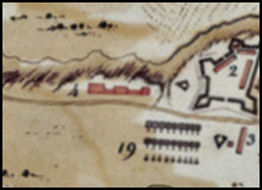
The 1763 Rocque map (below left) looks identical to the 1759 Hulbert map, showing suttlers' cabins along both sides of the Forbes Road. The 1761 Lukens map (below right) shows two parallel lines of suttlers' cabins flanking both sides of Forbes Road. In addition, eight suttlers' cabins extend to the south side of Forbes Road although a road between the two rows (presumably present-day Juliana Street) is not shown. 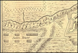
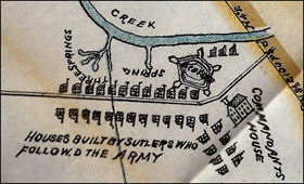
The Lukens map is the only one showing suttlers' cabins anywhere other than along Forbes Road. The Commandant's House, which actually stood to the southwest of the fort, is, in the Lukens map, shown to the southeast. If one error exists, can you trust the map to not contain any other errors? If the map is assumed to be accurate, why is the road that would become Juliana Street not shown at all? Rather than being the only true and accurate map, the Lukens map is probably inaccurate. The Lukens map does not look like the formal suryevor's plans for which John Lukens was noted. It resembles a rough drawing made in the field, and perhaps intended to be used as the basis for a more detailed rendering. If the Lukens map was just a field drawing, did Lukens intend exactly eight suttlers' cabins to be shown along a side road (Juliana Street) or was he simply suggesting that 'many' were clustered away from Forbes Road? Certain historians have suggested that the Lukens map indicates that the Mann house might have been one of the suttlers' cabins. While that is definitely a possibility, there is no way to prove such a conjecture. As already noted, in view of the fact that the Lukens map is the only one of the four contemporary maps to show suttlers' cabins located away from Forbes Road the questions arises, 'Why is it the only one?' and 'Why do three other maps differ from it?' To determine if the building previously known as the David F. Mann House would qualify as the oldest existing structure in Bedford County, a number of other structures should be noted. A number of identified structures were built in the vicinity of Fort Bedford from the time that the fort itself was constructed on the bare hilltop in 1758 and 1771 ~ the year in which Bedford County was erected out of Cumberland County. All of them, with the exception of one, are no longer standing. They are all noted here for the purpose of determining where, in the chronological timeline of the structures, the David F. Mann House would have been positioned. According to local tradition, the Waugh-Patton House in Everett is claimed by the owner as being the oldest structure in the county. [Newspaper article, Built Circa 1738 Patton House May Be Oldest In County, in Bedford Inquirer, issue of Friday October 1, 1976, p 1.] It supposedly was built by John Patton circa 1738. The tradition is based on a tenuous assumption that because John Patton purchased 200 acres 'west of the Susquehanna' in 1734 and an additional 250 acres 'along the Juniata' in 1736 while residing in Lancaster County, that he built this house in 1738. There exists no documentary evidence to support the tradition. John Patton did not 'purchase' any land in the sense of a grantee obtaining land from a grantor. No one owned any tract of land in this region prior to 1734 to be able to 'sell' it to Patton. Also a check of the warrants obtained by Lancaster County residents show that John Patton obtained only one warrant ~ for 250 acres on 26 March 1736 ~ but it was not for lands along the Juniata, but rather along the Octarara Creek. And he did not patent it, suggesting that he never actually settled on it which would imply ownership. Also, the structural elements of the house do not support the current owner's claims that it exhibits elements of the Transitional style (which the owner cited as ranging between 1500 and 1800), so the claims by the owner are inadequate to have it qualify as the oldest structure in Bedford County. There is another log and stone structure that has been claimed to date to 1738. It stands along the hillside in Cumberland Valley Township near Centerville. Prior to Colonel George Washington cutting a road between Fort Cumberland and Fort Bedford in 1758, there existed no road through the Cumberland Valley. Washington, like Bouquet, kept very detailed notes. He made absolutely no mention of finding a house standing in the forest to which and from which no one could travel. There exists no documentation such as land warrants or patents to suggest anyone obtained the land upon which this building stands. The tradition that this house was built in 1738 exists solely in the fact that a board was engraved with the number 1738 and hung on the side of the log structure. Until a scientific analysis is made on this building to determine its actual age, the 1738 claim must be considered a myth. At the same time that the stockade fort was being constructed, Christopher Lems built his own substantial stone house in either 1758 or 1759. At least that is local tradition. Mr. Lems did not obtain a warrant for any land in the vicinity of the newly built Fort. A date, therefore, is not available to even make an educated guess as to when the house would have been built. Christopher Lems is believed to have arrived with the British Army. He constructed his house a short distance to the west of the stockade fort, along the north side of Forbes Road. The road lay in a mostly direct east/west orientation as it passed the Fort. Christopher Lems likewise constructed his house with the walls oriented to the compass points. Captain Lems, as he was known, might have been associated with Colonel Henry Bouquet prior to the army's arrival here. He certainly became well acquainted with Bouquet once the fort was built and his own house was completed. It was claimed by early historians that when Colonel Bouquet would come into this region, he often stayed overnight at Lems' house, so much so that the building became known as the Bouquet House. Lems was not mentioned in any public record and did not even appear in any of his friend, Henry Bouquet's writings until 14 December 1760. [Louis M. Waddell, John L. Tottenham and Donald H. Kent (eds.), The Papers of Henry Bouquet, Volume V., The Pennsylvania Historical and Museum Commission, Harrisburg, 1984, p 174.] The large stone building stood until 29 March 1901 when the Hartley Bank Fire destroyed it and the adjacent Blymyer Building. Currently, the Cove Creek Outfitters store occupies an Italianate structure built partially on the site of the Lems/Bouquet House and partially on the site of the Blymyer Building. Also believed to have been constructed in 1758 concurrent with the construction of the Fort was a large log structure along the south side of Forbes Road and opposite to the Lems/Bouquet House. In the absence of a formal town plat, the log house was constructed slightly angled (13 to 15%) in relation to Forbes Road. The log structure was variously known as the Commandant's House, the King's House and the Old Fort House. It was constructed by the soldiers concurrent with their construction of the Fort. The first two names referred to the fact that it was intended to serve as officer's quarters (or barracks) while the third name referred to the tradition that it had been built earlier as a fort by Colonel John Armstrong. In two lectures he delivered at the Court House in 1886, Charles N. Hickok expressed certain 'facts' of history, some of which concerned the King's House. [Charles N. Hickok, Bedford in Ye Olden Times, Gazette Publishing Co., Bedford, 1907, pp 15-16.] According to Mr. Hickok: "The evidence is conclusive that this building was standing in 1755. It was most likely built in 1754 or even earlier." Just what that 'conclusive' evidence was, was never revealed by Mr. Hickok. In fact, the 'evidence' is that the published Pennsylvania Archives and Colonial Records contain no information regarding the construction of a 'commandant's house' in conjunction with the construction of Fort Bedford. The turn-of-the-century historian followed that statement with: "The fort in which it stood was a pentagon, with silent [sic] points at each angle." One thing is very clear: the King's House, or Old Fort House, even if it was standing in 1758 when the fort was constructed, did not stand inside the fort's stockade wall (at least not according to any public record). On 9 April 1757, Governor William Denny submitted a report to the Proprietaries in which he stated: "As in the Spring Parties of the Enemy Indians from the Ohio were expected to renew their Incursions, at the latter end of March I ordered Lieutenant Col. Armstrong to encamp with a Detachment consisting of Three Hundred Men near Ray's Town, a well chosen Situation on this Side the Allegheny Hills, between Two Indian Roads, the only known Tract of the Indians to invade this Province." [Samuel Hazard (ed.), Pennsylvania Archives, Series I, Volume III, Joseph Severns & Co., Harrisburg, 1853, p 117.] In his 1932 book, Fort Ligonier and Its Times, C. Hale Sipe claimed: ". . . and that the assembling place of the southern troops should be Bedford, where a stockade (Fort Bedford) had been erected by Colonel John Armstrong in 1756." [C. Hale Sipe, Fort Ligonier and Its Times, The Telegraph Press, Harrisburg, 1932, pp 26-27.] Sipe possibly interpreted Denny's wording of "to encamp with a detachment" as meaning he actually constructed a stockade. In 1939, Solon and Elizabeth Buck, in their book, The Planting of Civilization in Western Pennsylvania stated that: ". . . and in June he [Forbes] sent Bouquet forward with the advance division to Raystown, over the road that had been cut by James Burd in 1755. At this point a stockade had been constructed by Pennsylvania militia in 1757, which was now enlarged and strengthened and named Fort Bedford." [Solon J. and Elizabeth Hawthorn Buck, The Planting of Civilization in Western Pennsylvania, University of Pittsburgh Press, Pittsburgh, 1939, p 90.] Their statement suggests that Bouquet found the remnants of a previously built fort and simply enlarged it. The only problem with these statements is that no evidence exists in the contemporary public documents to corroborate the belief that any fortification existed near Raystown prior to the Forbes Expedition of 1758. In fact, Armstrong was denied the monetary funds to construct the fortifiaction he is claimed to have constructed. Also, no mention of finding any previous fortification at the site was made by Bouquet when he arrived in June of 1758. In view of all the other details noted by Bouquet in his letters, it is surprising that he would neglect to mention either finding or 'enlarging' an earlier stockade. A two-story stone addition was built to the west end of the original log structure in 1790 by Henry Wertz. The stone addition brought the north end of the building almost touching on Forbes Road. It is believed that it was after Wertz added the stone portion, that the business was operated as the Rising Sun Tavern. While the log building was operated as the Rising Sun Tavern, the stone addition might have been utilized by the innkeeper and his family as a dwelling. It could also have provided storage space for wine, whiskey and rum barrels, bottles and other tavern inventory. The property on which the Rising Sun Tavern stood (the original Lots #1 and #2 on the Lukens Survey) along with the property on which this half-timber structure stands (the original Lots #3 and #4 on the Lukens Survey) passed through a succession of owners. Thomas Moore purchased the property in 1814 and added a brick portion onto the south end of the Rising Sun Tavern. On 18 December 1885, the structure caught fire and the original log portion burned so hot that the fireplace chimney collapsed into the stone portion, destroying it. The property was eventually occupied by the Ridenour Building. The one structure that was built during this time period, and which still stands at the present day was the Espy House. The small stone building was constructed circa 1771 by Thomas Smith. The building's west wall would have been in line with the Fort's west stockade wall, but was situated outside of the Fort in the vicinity of the moat that surrounded the Fort. The structure is noted for two things. Arthur St. Clair maintained his office as Clerk of Courts in the cellar room. And famously, George Washington stayed overnight in the house then owned by David Espy when he led the United States Army westward to quell the Whiskey Rebellion. Due to George Washington's connection to it (and because of the fact that until now, the existence of a half-timbered structure was unknown), the Espy House has, for decades, been heralded as the oldest extant structure in both the Borough and the County. None of the available maps or drawings of Fort Bedford show the powder magazine. It would no doubt have been located outside the stockade to safeguard the supplies. Powder magazines were often underground, or partly buried into the ground and roofed over, to minimize an explosion if hit by an enemy's cannonballs, musket shot or even a flaming arrow. It has been suggested that Fort Bedford's powder magazine was located in a part of the basement of the David F. Mann Building at 111 S. Juliana Street (original Lot #2), home of the Peppercorn Market today. [William A. Jordan (ed.), The Official Program of the 1971 Bicentennial, Bedford County Bicentennial Commission, 1971, p 25.] In a letter written by Lieutenant Lewis Ourry to Colonel Henry Bouquet on 13 November 1759 from Fort Bedford, he commented on the slowing down of work there (and at certain of the posts between Bedford and Ligonier) ~ in essence, implying that work on the fortification and its surrounding buildings had been ongoing until then. He stated: "All the Artificers, except three Smiths, & as many Wheelwrights, & one Saddler, and some Carpenters / Soldiers / have been discharg'd Some time. I have wrote to Mr. Blythe to send me the Saddler from fort Cumberland that I may discharge the two together. This week I shall dismiss the Carpenters except two, having completed all the Stores, & Granaries, & finish'd the necessary House & put the Guns under Cover, and perfected my Waggon-Bridge. I have also a Stock of Boards, seasoning against they may be wanted. In a little time we may discharge the Blacksmiths also, as I have set up a Smith, who is now at Work for himself in the Gunsmiths new House. And Frazer has built himself a Shop, intending to Work at his Trade." [Louis M. Waddell, John L. Tottenham, Donald H. Kent (eds), The Papers of Henry Bouquet, Volume IV, The Pennsylvania Historical and Museum Commission, Harrisburg, 1978, p 70.] Of special interest is the portion of the letter in which Lieutenant Ourry stated: "and finish'd the necessary House & put the Guns under Cover. . ." Putting the guns under cover would imply placing them in a powder magazine. And to say that that was accomplished following the completion of the 'necessary House' would imply that the powder magazine was not just a hole dug in the ground but a pit enclosed by a structure above ground. A powder magazine needed to be substantial and capable of keeping guns and ammunition secure from enemy and safe from the weather. A powder magazine did not need to be constructed of stone unless the fortification was intended to be in use for an extended period of time and to withstand constant bombardment. Likewise, a powder magazine did not need to be constructed of logs, especially when so many logs had been used in the construction of the stockade fort itself. A frame structure enclosing a dug pit, on the other hand, and especially one constructed of half-timbering, would have been an ideal solution to providing a secure, but quickly and inexpensively constructed building. Large trees would not have been required to provide the framing timbers. Smaller growth, not suitable for the construction of the stockade fort and its buildings, would have provided enough timber for a half-timbered construction. Also, the unfired, sun-baked bricks needed to infill the walls would have been easily made on site and as needed. Various Indian Traders had established their trading posts in the region that would become Bedford County as early as the 1740s. Also, various local families have family traditions, although not proven by public documents, that their ancestors were settled in this region prior to the Forbes Expedition of 1758. Also, coincident with the construction of the fortified supply depot named Fort Bedford, there were a number of buildings constructed in the vicinity of present-day Bedford Borough. Despite the fact that any or all of those structures might have been built prior to the date on which the building known as the David F. Mann House was constructed, none of them have survived to the present day. A powder magazine for Fort Bedford is believed to have been established outside of the stockade wall, at a slight distance to the west. It would have been located away from the Fort for the purpose of safeguarding the Fort in the event of enemy attack. Fort Bedford was constructed in the Forbes Expedition to serve as a supply depot and a substantial amount of supplies were stored within its stockade walls. If the powder magazine had been established within the stockade walls, and if an enemy attack resulted in the powder magazine being hit with a flaming arrow or musket shot, it would pose a threat to the entire Fort and the supplies stored within it. The structure that would eventually become known as the David F. Mann House was possibly built concurrent with the construction of the Fort as an enclosure of the powder magazine. The earliest beginning date for the construction of the fortification and all of its surrounding buildings and features was 24 June 1758. If the theory that the structure of the David F. Mann House was the original powder magazine for Fort Bedford, it would have been completed prior to 13 November 1759, the date that Lieutenant Lewis Ourry sent a letter to Colonel Henry Bouquet in which he stated that he had "finish'd the necessary House & put the Guns under Cover". It is important to realize that, even if this half-timber structure was not originally constructed as an enclosure for Fort Bedford's powder magazine, it is still highly significant for being the only half-timbered structure to exist in Bedford County ~ evidence of being constructed in the earliest architectural style represented in the county: Colonial. Although the exact date of its construction might not be determined, this structure would, no doubt, be older than the currently accepted and celebrated 'oldest house' in the county: the Espy House.