 The Rising Sun Tavern was perhaps the most venerable of the early taverns of Bedford County. It was one of the first buildings to be constructed in the vicinity of the fort, but it was not the first tavern to be operated in this region. The building was constructed for a different purpose. The following will discuss how that building was used in the one hundred and twenty-five years of its existence.
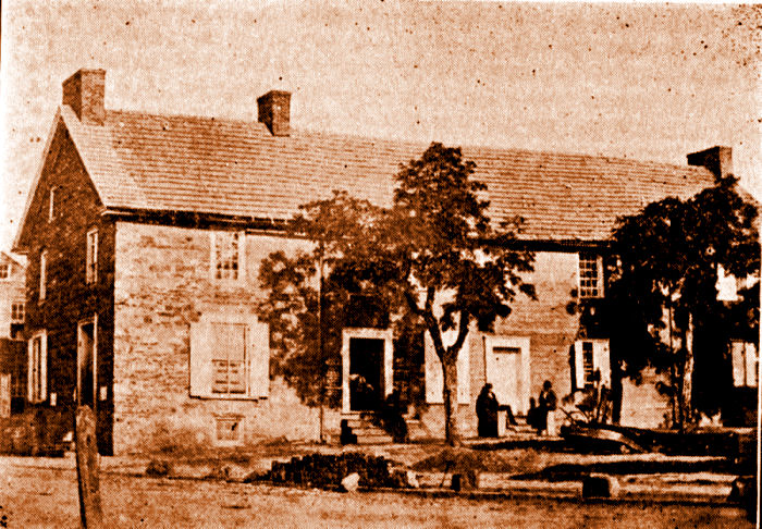
There was a belief by some historians that the original two-story log structure, that later became known as the Rising Sun, was constructed in 1755, three years before the fort was built. Despite the fact that Colonel Henry Bouquet did not mention any structures occupying the small hill upon which he chose to construct the fort, early historians wishing to make the history of the county that much older, created the story about Colonel John Armstrong's fort-in-a-small-log-building, and the structure was called the Old Fort House by some. In two lectures he delivered at the Court House in 1886, Charles N. Hickok expressed certain 'facts' of history, some of which concerned the Old Fort House. According to Mr. Hickok: "The evidence is conclusive that this building was standing in 1755. It was most likely built in 1754 or even earlier." Just what that 'conclusive' evidence was, was never revealed by Mr. Hickok. In fact, the 'evidence' is that the published Pennsylvania Archives and Colonial Records contain no information regarding the construction of any fortified structure by Armstrong. Colonel John Armstrong had been chosen to mount an expedition to destroy the Amerindian settlement at Kittanning near the end of 1756. Kittanning was the site from which the Amerindians (perhaps goaded on by the French) launched a number of attacks on Euro~American settlers. On 09 April 1757, then-Pennsylvania Governor William Denny submitted a report of recent affairs to the Proprietaries in which he stated: "As in the Spring Parties of the Enemy Indians from the Ohio were expected to renew their Incursions, at the latter end of March I ordered Lieutenant Col. [John] Armstrong to encamp with a Detachment consisting of Three Hundred Men near Ray's Town, a well chosen Situation on this Side the Allegheny Hills, between Two Indian Roads, the only known Tract of the Indians to invade this Province. He had further Directions to employ Spies, and send out ranging Parties; by these Precautions the Inroads of the Indians might have been prevented, or their Retreat cut off, which woud probably have hinderd future Incursions. For this Service, a few Horses, some Forage and a small Matter of Camp Equipage are wanting. I cannot prevail on the Commissioners to advance the necessary Supplies, so that I doubt this Expedition will miscarry for want of a trifling Expence." In his 1932 book, Fort Ligonier and Its Times, C. Hale Sipe claimed: ". . . and that the assembling place of the southern troops should be Bedford, where a stockade (Fort Bedford) had been erected by Colonel John Armstrong in 1756." Sipe possibly interpreted Denny's wording of "to encamp with a detachment" as meaning he actually constructed a stockade and fort. In any case, the reader might have noticed that Sipe misidentified a possible fortification built by Colonel Armstrong as 'Fort Bedford'. In 1939, Solon and Elizabeth Buck, in their book, The Planting of Civilization in Western Pennsylvania stated that: ". . . and in June he [Forbes] sent Bouquet forward with the advance division to Raystown, over the road that had been cut by James Burd in 1755. At this point a stockade had been constructed by Pennsylvania militia in 1757, which was now enlarged and strengthened and named Fort Bedford." The only problem with these statements is that no evidence exists in the contemporary public documents to corroborate the belief that a fortification existed near Raystown prior to the Forbes Expedition of 1758. Also, no mention of finding any previous fortification at the site was made by Bouquet when he arrived in June of 1758. In view of all the other details noted by Bouquet in his letters, it is surprising that he would neglect to mention either finding or 'enlarging' an earlier stockade. Colonel John Armstrong believed that a fort should be built near the trading post of John Wray. He, in fact, suggested the idea to Governor Denny. In a letter written from Carlisle on 05 May 1757, Armstrong stated: "The Coming of the Cherokees and Catawbas appears to be a very favourable Providence. . . and prompts me to propose to your Honour what I have long ago suggested to the late Governor and Gentlemen Commissioners, that is the Building a Fort at Ray's Town, without which the King's Business and the Country's Safety can never be effected to the Westward." His rationale for such a fort was that "To this Place, were we there encamped or fortified, might the Southern Indians be brought frequently from Fort Cumberland, provided the Necessaries of Life and of War cou'd there be given them; and from it might proceed Patroling Parties to spy, waylay, intercept, &ca. . ." The letter reveals that Armstrong definitely was in favor of building a fort on the east side of the Allegheny Mountain, but it does not prove that any fort ever actually got built. One thing is often overlooked by those who claim that a fort had been constructed by Armstrong before the Forbes Expedition arrived in this wilderness region. Although Governor Denny agreed with the idea of erecting a fort, and thereby suggested to Colonel Armstrong that he indeed erect a fort at Raystown (and garrison it with 500 soldiers), Armstrong never acted upon that suggestion. Colonel Stanwix advised against Armstrong using his own money and ultimately, the Provincial Assembly of Pennsylvania rejected the request for the necessary funding. Charles Moore, the clerk for the Provincial Commissioners sent a letter to Colonel Armstrong dated 21 May 1757, in which he stated: "We agree to the Governors proposal of permitting Colonel Armstrong to provide Horses and other necessary's for the said Expedition, in case the same do not exceed Seven hundred & fifty Pounds, & if they shou'd, he is then to communicate his Design to the Governor immediately to be further considered, agreeable to his Honours recommendation." Colonel Armstrong responded to the clerk's message by noting that: "I have wrote the Governor my reasons for not immediately acknowledging ye receit of the Minute made at Lancaster, which in fact was only a permission to lead myself into inextricable difficulties, however Colonel Stanwix wou'd not admit my doing it, and is much displeas'd that any thing of the Sort shou'd be offer'd without depositing the Cash in some persons hand or other. . ." A year later, on 05 April 1758, the Provincial Commissioners filed an Answer. . . to several Charges made against them, in which they commented on the rejection of funding of the proposed fortification: "The Governor, on the Thirteenth Day of May last, did request, that we would defray the Expence of erecting a Fortification at Ray's-Town, 'to be garrisoned with 500 Men, in the Pay of the Province. When we considered the advanced Situation of this Place towards the Enemy, its great Distance from the inhabited Parts of the Province, the vast Sum of Money which must be necessarily expended in erecting a Fortfication there, the Expence of escorting Provisions to support 500 Men, and the great Difficulty of defending it when finished, we rejected the Proposal, - as it was manifest it would require more Money than was at that Time subject to our Draughts for defraying the whole Expence of the Year, and could only serve to waste the public Money, answer the private Purposes of Individuals, and to load the Country with a Debt it could not possibly bear. We have also thought it our Duty to refuse to comply with the Governor's earnest Request, of throwing into the Hands of the Military Officers Sums of Money, from Time to Time, to be disposed of by them as they should think proper, without ever knowing to what Use they were to be appropriated. . ."
So according to the records maintained in the Pennsylvania Archives, Colonel John Armstrong's proposal to construct a fort near John Ray's trading post died due to lack of funding. Despite the fact that the subject of Colonel John Armstrong building a fort near John Wray's trading post was ended and not discussed again in the public records and despite the complete lack of any evidence that it ever was built, the myth of an Old Fort House persisted. That myth was supported by historians, such as Charles Hickok, who, as noted above, claimed that the building was built as early as 1754 ~ three years before it was even suggested by Colonel Armstrong. A Pennsylvania Historical Marker was erected in front of the Bedford Candies shop at 106 E. Pitt Street to commemorate the King's House. The Marker reads: "A log structure, built prior to 1761, stood on this site. Known, also, as the Commandants House; later as 'Rising Sun Inn.' Occupied by British officers until close of French and Indian War. Destroyed by fire, Dec. 14, 1885." In the 1950s, Bedford County historian Annie M. Gilchrist claimed to have discovered much of the history of the Rising Sun Tavern. She wrote about it in the Bedford Inquirer in a two part column under the banner, 'Down Memory Lane'. Gilchrist equated the original structure, which was known variously as the Old Fort House, the Commandant's House and the King's House, with a cabin claimed to have been built by Captain Lewis Ourry in 1760/61. This is an important point to note when considering the history of the half-timber structure alongside the history of the Commandant's/King's House. The half-timber structure is believed to have been constructed circa 1758 concurrent with the construction of the fort itself. If Annie Gilchrist's research was accurate, and the Commandant's/King's House was built circa 1760, then the use of the half-timber structure as a mess hall/tavern for the British Army officers would not have happened for at least two years. The initial construction and use of the half-timber structure may very well have been as the fort's powder magazine/armory. And its use in association with the Commandant's/King's House would have been a secondary employment. Annie Gilchrist's approach to the subject (which was to suggest that it was Lewis Ourry who had the Commandant's/King's House built between 1760 and '61) seems plausible. On 06 April 1760, Lieutenant Ourry wrote to Colonel Bouquet, who at the time, was in Philadelphia: "I have reserved a proper Lot to build a House for the Commanding Officer &c: and have the principal Logs on the Spot. & have order'd the rest of the Stuff to be got ready in the Woods. . . One could assume that Lieutenant Ourry began work on the Commandant's/King's House in the Spring of 1760, having noted in his letter that he had the logs on the spot. It should also be noted that he had chosen to build the house for the commanding officer. The fact of the matter is that there is no evidence to pinpoint exactly when the building was begun. And it should be noted that at no time, and in no contemporary document, did Ourry identify the actual location of the 'house' he was constructing. Gilchrist and other historians might have associated the wording of Ourry's letter, in which he referred to the building of a "House for the Commanding Officer" with the name the 'Commandant's House' by which the log structure, that would later house the Rising Sun tavern, was sometimes known. And who's to say that that connection/assumption is incorrect? It certainly makes sense that if Ourry was constructing a 'house' for the fort's commandant, then the structure that would be known as the Commandant's House would no doubt have been the same thing. The other name sometimes given to the building that Ourry was constructing was the 'King's House'. As just mentioned, if the house was being built to provide living space for the Commandant of the fort, the name 'Commandant's House' was appropriate. But there is also the belief that the building was not built solely for the use of the Commandant of the fort. The British Army was the King's army. Therefore the troops in the King's army served the King (George II). The name of the King's House would have been appropriate if the house was intended to also provided living space (i.e.barracks) for the King's Army's officers. Ourry made no mention of the building of the Kings House for over a year. At the end of January 1761, Ourry was reassigned and left Fort Bedford, with Lieutenant Chichester Fortescue Garstin in command of the fort. In a letter to Bouquet dated 25 January 1761, Ourry stated: "Since my last of the 23rd I have Settled Lt. Garstin in the full Possession of this Garrison, and acquainted him with the Several Particular Duties that are expected from the Officer Commanding at this Post." Ourry then wrote to Bouquet on the 30th of January to let him know that he would be setting out the next day for New York. He returned three months later. From Lancaster, on 27 April, Ourry wrote to Bouquet: "I am thus on my Journey to Bedford where I hope to be about Wednesday next come Se'enight." On 02 May, Ourry wrote to Bouquet from Carlisle and then on the 13th he wrote to Bouquet from Fort Bedford: "I arrived here yesterday Afternoon, and left my Waggons between Juniata & this Place. I expect them in every Minute. I have hardly time to look about me, but have already seen too much of the Waste, and Childish Damage commited here by Lieut. Garstin." The repair of damages at the fort, caused by the lack of discipline, and the need to repair the roads between Bedford and Pittsburgh, which had been neglected and allowed to deteriorate, demanded the major part of Ourry's attention when he got back to Fort Bedford. On 02 May Ourry wrote that: "I have no Carpenters to finish the House for a State of which I must refer you to Mr. Myers." It might be presumed that he was referring to the Commandant's House that he had begun the previous year. It would not be until October that Ourry mentioned anything in relation to the house again. On 16 October 1761, Lewis Ourry wrote to Colonel Henry Bouquet that: "I wrote lately to Captn Gordon to send me down, (as soon as he could Spare them) some Carpenters & Joyners with proper tools for making Sashes. The only thing the General [Robert Monckton] particularly Order'd me, was to finish the House and it has not been in my Power to accomplish it, there being no Carpenters here but bunglers; So that you will be obliged to Sleep again in my old Hutt, where I heartily wish to see you Soon." It can be assumed, since Ourry needed "some Carpenters and Joyners" to make the sashes, that the building was essentially constructed, but just needed the finishing touches. In fact, it should be noted that Ourry stated that the orders he had received from the General "was to finish the House"; he didn't say anything to the effect of starting the construction but rather to finishing it. And so it can be assumed that the bulk of the construction of the Commandant's/King's House was through the summer and into the autumn of 1761 under the direction of Lewis Ourry. [It might be noted here that in her assessment of Ourry's and Bouquet's exchanges, historian Annie M. Gilchrist, in the article, Down Memory Lane: The Rising Sun Tavern, made the assumption that the 'my old Hutt,' reference by Ourry, implied 'the General's Hutt.' From what evidence she derived that assumption, is anyone's guess. Lieutenant Lewis Ourry was noted for his interest in the theatrical, often including in his letters to Bouquet imaginative musings. It is my opinion that Ourry was 'waxing poetic,' or rather using expressive language to describe a mundane topic. Ourry wrote to Bouquet again on 25 October 1761, stating: "I Suppose I may depend on passing my Winter in this Solitary Hutt. . ." The author of Chapter Four of the Fort Bedford Bicentennial souvenir book, edited by Hugo K. Frear, took Gilchrist's assumption a step farther on page 35 by stating: "The Hutt to which he (Ourry) referred was the 'King's House'. . ." without noting the source of the statement.] Historian Gilchrist further concluded that the 'house' was finished by 16 November 1761 because she quoted another Ourry to Bouquet letter as stating that "I made him bring a Chest and a large Bag in the New House." Although it was a good assumption, just because Ourry noted that a chest and bag were carried into the 'new' house in a letter he wrote on 16 November, there's no reason for one to assume that the construction was completed on the same date as that letter. As noted previously, John Armstrong, a Deputy Surveyor following Surveyor General, John Lukens' directive, laid out the Proprietary Manor of Bedford on 29 October 1761. The so-called 'Commandant's House' is shown on that survey located on the south side of Forbes Road, opposite to the stockade fort. It would suggest that Gilchrist's assumed completion date of the house on 16 November was off by eighteen days. And it should also be noted that Armstrong could have labeled the item on his survey with its eventual name, whether or not it was completed on, or prior to, the day he made the survey. 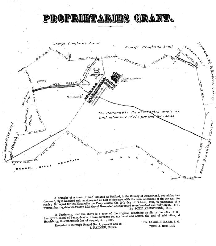
There is one thing that can definitely be stated, though. The claims that the structure had been built by John Armstrong's troops as a 'fort' when he came through this region in 1757 (thereby giving it the name, Old Fort House) can be proven completely false. If it's completion date is definitely attributed to the Autumn of 1761, there is no way that the log building could have been standing four years earlier. Also, the suggestion made by the text of the Pennsylvania Historical Marker, that it was "Occupied by British officers until close of French and Indian War" would mean that it was occupied for only two years as officers' quarters. The French and Indian War was officially over in 1763. Ourry's letters along with Armstrong's survey effectively answer the mystery of who built the King's House and the date (at least the year) of its construction. John Lukens, the official Surveyor for the Province of Pennsylvania, was commissioned in 1766 to lay out a village within the Manor of Bedford located in the western frontier of Cumberland County. The region within the vicinity of Fort Bedford, at the time, was occupied by three substantial buildings and perhaps a few smaller structures. In this case, the word 'substantial' refers to the physical size of the structures. Those three substantial buildings included Fort Bedford, the Christopher Lems stone structure and the two-story log structure known by the name of the Commandant's or King's House. The few smaller structures would have included the half-timber house and a couple sheds and shacks constructed by the suttlers who were following the British Army. Despite the absurd claims by the historians of the early-1900s that the area in the vicinity of the fort was "Bedford, formerly Raystown", there was nothing remotely resembling a village here when Lukens arrived to actually lay out a town plat.
The two-story log structure was built on Lot #1 close to, but not bordering exactly on, the west end of that lot. Looking down on the lot, the Commandant's House was situated about one-third of the lot's total length from the west end. Because the log structure was already standing in 1766 when John Lukens laid out the town, it wasn't built to accommodate a pre-existing plan. And it is known that Lukens based his survey on the stone house built on the opposite (north) side of the Forbes Road by Christopher Lems. That was the building commonly known as the Bouquet House because Colonel Henry Bouquet would stay there when he visited after the Forbes Campaign. The Commandant's House, being a standard log construction of the 18th Century, would have been between twenty and thirty feet in length. Although the exact dimensions and location of the log structure is unknown, it's south end probably was close to the south boundary line of Lot #1 / north boundary line of Lot #2. A stone addition was built circa 1790 by Henry Wertz. It was attached to the north end of the log structure and extended the length of the whole building to about sixty feet, the north wall reaching to Pitt Street. The actual dimensions of the building are forgotten now, but a photograph of the south side of Pitt Street, dated 1880, shows the north end of the structure.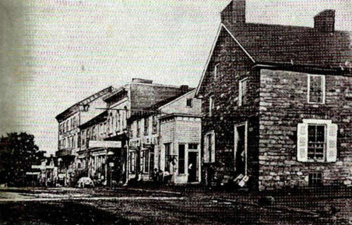
The image of the stone north end reveals a door and one window occupying that north end of the building. The expanse of stone between the door and window looks like it could accommodate another window or door; it looks like the width of the building could have been fifteen to twenty feet. The northwest corner of the stone structure appears to be touching the line of the other buildings on that block, while the northeast corner is set back perhaps five to six feet from that same line. [A wood structure was built to connect the east side of the stone building with another wood frame building to the west. Four rafters of the connecting structure are visible in the 1880 photo. At sixteen inches on center, the rafters would have spanned five and one-third feet.] Plotting a twenty feet wide structure with the west corner point on a line and the east corner point five feet from that line reveals that the building would probably have been situated at about a 14.47 degree angle from Pitt Street. The first Sanborn Fire Insurance map that was produced for Bedford Borough was published in 1885, just prior to the fire that destroyed the Rising Sun Tavern building. That map confirms the 14 degree angle of the building on the northeast corner of Pitt and Juliana Streets. [Be aware that the image below is oriented with the north to the left and the east to the top.]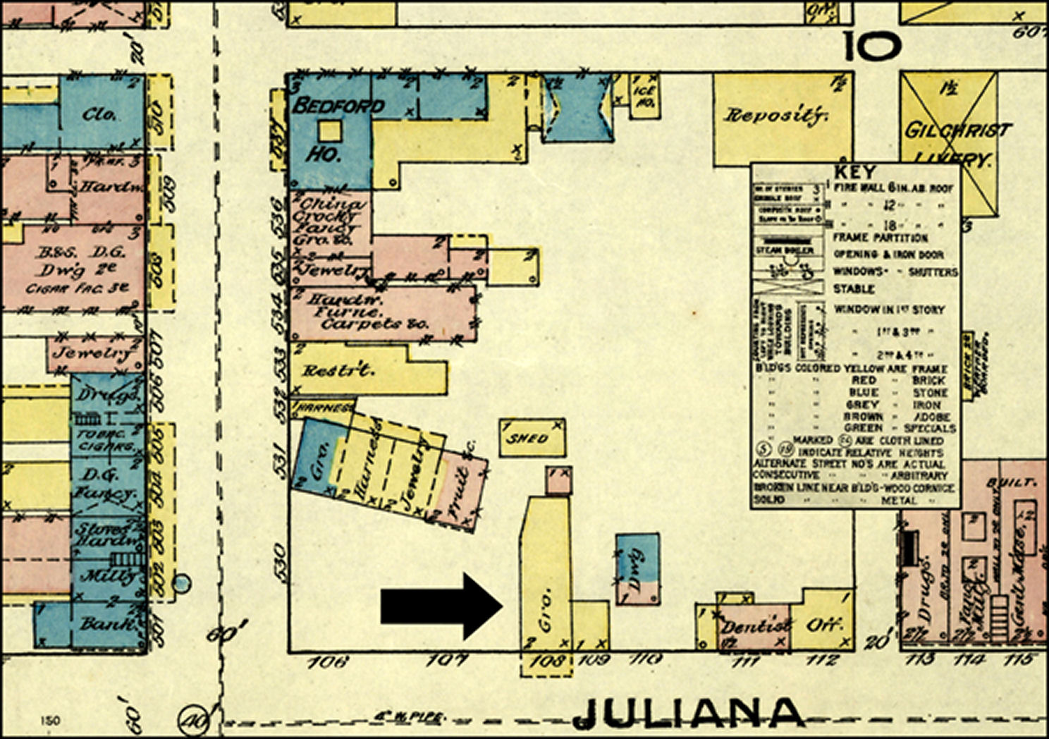
A number of other buildings fronting on Pitt Street were constructed to the east of the Rising Sun Tavern log and stone structure. The remainder of Lots #1 and #2, to the west of the Rising Sun, remained as an open field, or yard for many years. The three substantial structures that would have been in existence in 1766 when John Lukens arrived to lay out a village plat are suggested in the 1885 Sanborn Fire Insurance map shown below. [The orientation of the map has been returned to north at the top.]
In 1761, concurrent with the construction of the two-story log building known as the Commandant's House, the land upon which it stood was claimed by the Penn family as part of the Manor of Bedford. And then, in 1766 when the town was effectively founded with the survey performed by John Lukens, the particular tract upon which the Commandant's House stood was designated as one of the twenty-two lots reserved for the use of the Proprietors. Apparently, since the structure was built by the British Army circa 1761, it continued to be owned and used by the British Army for the next five years. [The British Army was removed from Fort Bedford in 1766 with the conclusion of Pontiac's Rebellion.] The instructions given to Lukens when he made his survey was that certain lots were to be designated as owned by the Penn family as the Proprietaries of Pennsylvania. That directive would have included Lot #1, on which the Commandant's House stood. The first person to purchase the property consisting of Lot #1 from the Proprietors was Henry Wertz. Wertz apparently obtained a patent for Lots #1 and #2 from the Proprietors on 17 November 1788. I note 'apparently' because no record of the patent can be found in the archives of Pennsylvania Land Records. The information, as claimed by Annie M. Gilchrist, comes from a deed made out on 23 September 1811 by which Henry and Margaret Wertz sold the tract to Joshua Johnson. It must be remembered that the original structure was a log building. A two-story stone addition was built to the north/west end of the original log structure in 1790 by Henry Wertz. It is believed that it was after Wertz added the stone portion, that the business was operated as the Rising Sun Tavern. Henry Wertz held a tavern license off and on for a number of years prior to 1790, so it cannot be assumed that the Rising Sun was his first tavern. During the January 1778 Sessions of the Court of Quarter Sessions, Henry Wert was convicted of operating a 'tipling house', meaning that at that time he was selling liquor without a valid license. Then, on 13 October 1779, Henry Wertz's request for a tavern license was approved. The deed that transferred ownership of Lots #1 and #2 to Joshua Johnson also included sixty feet of the east end of Lot #3 (which was claimed by Wertz because he had erected a stable partly on Lot #2 and partly on Lot #3). Lot #3, which was the lot upon which the Half-Timber Structure was located, had been purchased by Felix Mellan from the Proprietaries on 19 September 1789: "which said mesuage and lot of ground was by Patent under the hand and seals of Anthony Butler and John F. Mifflin Attornies [illegible] appointed for John Penn the Younger and John Penn Esquires the Proprietaries of the late Province (now State of Pennsylvania) bearing date the Nineteenth day of September in the year of our Lord one thousand seven hundred Eighty nine for the Consideration therein mentioned sold and Conveyed to the said Felix Mellan as by the said Patent. . ." Lot #3 was then sold, on 10 October 1799 to Henry Wertz. The transaction had been handled by Mellan's estate administrators Hugh Barclay and Josiah Espy. That transaction noted the inclusion of a stone dwelling and stable and a brick storehouse. It also noted that Felix Mellan had made a living as a merchant, and that Henry Wertz was noted, in that document, as an innkeeper. On 27 September 1777, a Court of Petty Sessions was held at the 'house' of Henry Wertz. The assumption would be that this referred to the Commandant's/King's House structure, but theories have been put forward, since the discovery of the half-timber structure, that perhaps that building was used by the Wertz family as their residence, and therefore the court session might have been held there. Like most buildings of that time, the log structure was noted as having no floor besides the beaten-down earth over which it was built. The walls of hewn logs were left uncovered, i.e. un-plastered. Although the early historians do not specifically say, by the time that the stone addition was built in the 1790s, the original log portion was probably finished with wood flooring and plastered walls. Henry Wertz purchased additional lots in the town of Bedford. In 1795 a survey map of the town of Bedford, mimicking the original Lukens Survey map of 1766, showed the then-current owners of various of the lots in the town. Henry Wertz was shown as owning Lots #1 through #4 on that survey of lot owners. By the year 1800, members of the Penn family who had been established as proprietaries of the province, then state, of Pennsylvania had moved to Great Britain. Their proprietary role had been taken from them as a result of their loyalty to Great Britain during the American Revolutionary War. The Penn family may have lost their role as proprietaries, but they were not forced to forfeit ownership of their tracts of lands throughout the state. Anthony Butler no longer served the Penn family as their attorney to conduct land transactions. For transactions in Bedford County, George Woods represented the Penns. On 17 February 1800, a deed between the Penns and Henry Wertz was recorded in the Bedford County Court House. In that exchange Henry Wertz paid 39 pound sterling and 10 shilling for a tract of fifty-nine acres encompassing the land lying between Lots #3 and #10 in the town survey. On 06 March 1811, Henry Wertz Sr., conveyed a tract to his son, Henry Jr. That tract included the tavern site along with parts of Lots #1 and #2. The deed included the notation that the 'Improvements' included in the transaction consisted of "a stone dwelling House and brick Store House and Stone Stables. . ." The 'stone dwelling House' noted here more than likely referred to the stone addition Henry Wertz built in 1790 adjoining the original 1760/61 log structure. The text of the deed did not state that the 'stone dwelling House' was a separate building. On 30 October 1811, Henry Wertz Jr., sold the tavern site to Hugh Dennison, of Providence Township. Dennison presumably intended to make a living as an innkeeper in Providence Township; he would later build the large stone structure at the crossing of the Juniata River. Dennison had received a tavern license two years earlier, in 1809. The tract that he purchased in the town of Bedford from Wertz, for $4,000, was the one conveyed from Henry Wertz Sr., to his son just eight months earlier. Most historical references to the Rising Sun Tavern have claimed that Thomas Moore built a brick addition to the south/east end of the structure in 1812. Although the ownership of the property by Thomas Moore is accurate, the date on which he would have built the brick addition is off by two years. Hugh Dennison kept the property for just three years. Hugh and his wife, Polly, Dennison sold the property in October 1814 to Thomas Moore for $5,000. With the log and stone structure basically filling the sixty feet width of Lot #1, the brick section that Moore attached onto the south end of the structure would have extended onto Lot #2. It was probably, but not proven, during the period in which Thomas Moore owned the property that the original log structure was covered with wood clapboards as a means to weather-proof it. Most log buildings were covered with siding to protect the logs and it was only in the mid-1900s that people started to remove the siding because they wanted to see the logs. On 09 January 1819, a portion of the property became vested in David Mann via Sheriff Sale, and the tract containing the tavern and parts of the two adjoining lots were also sold to David Mann on 07 April 1820. On 18 January 1814, Henry Wertz had sold a portion of Lot #3 to William Gibson. On 17 December 1832, William and Elizabeth Gibson sold Lot #4 to David F. Mann. The transaction included the part of Lot #3 that Henry Wertz had sold to the Gibsons in 1814. It was afterward conveyed to Job Mann in trust and then again conveyed on 20 April 1830 to the Gibsons. Ultimately, David F. Mann became owner of all four lots in the 1830s just as Henry Wertz, Sr., had in the 1790s. The Rising Sun building, for half a century from the 1830s through the 1880s, was rented out to a variety of individuals as apartments and stores. A jewelry store was occupying the brick addition in the 1830s. The owner of that business, Axel Anderson, is claimed to have "invented and patented the use of silk threads in paper money for the U.S." according to historian Annie M. Gilchrist. Crane and Company of Dalton, Massachusetts also claims to have invented and patented the process. It is possible, though not proven, that Anderson worked for Crane and Company, and was the employee responsible for coming up with the idea. The Rising Sun building, (then owned by the heirs of the late David F. Mann) along with a number of other buildings, burned down on 18 December 1885. At the time, the four ground floor storerooms in the Rising Sun were occupied by Harry Gilchrist, a confectioner; R. B. Metcalfe, a saddler and upholsterer; J. M. Hoffer, a jeweler and White's Saloon. The second floor was occupied by two families: Mrs. A. W. Anderson and her three children and John Harris his daughter, Camilla and her husband Joe Diehl and their daughter, Missouri. The other buildings that would be involved in the conflagration included a small building owned by Simon Ling (which would be totally consumed) and a structure owned by Dr. J. A. McCullough, in which Dexter White operated a restaurant and bar. At around 11:00pm Mrs. Anderson was awakened, immediately smelling smoke from a fire that had started in the storeroom below her apartment. She called for help and a policeman heard her. He roused about a dozen other men, who responded to the call. After getting the families in the second floor apartments out safely, they forced the door of Mr. Metcalfe's storeroom open. They found it to be engulfed in flames. Some of the men went to the firehouse to retrieve the hose carriage, but one thing after another went wrong. There was difficulty getting the carriage out of the engine house. Then enroute, three of the wheels fell off. With the carriage lying where it dropped, the hose was spread out from it. In trying to couple a few lengths of hose together, it was discovered that the necessary reducers were missing. Nearly twenty minutes went by before the hose connections were obtained and water was made available to begin putting out the fire. Unfortunately, the high winds had fanned the flames more and the pressure of the water coming out of the hoses was very low. The men could not get ahead of the fire. The Everett fire department was called by telephone, but the man supposed to be answering their calls could not be aroused from sleep. The fire company at Huntingdon was also called, and they started out to help, but the buildings were lost before the Huntingdon crew could arrive. The Mann and McCullough buildings were both destroyed in the blaze. The large brick building to the east of the Rising Sun was owned by Captain S. S. Metzger. It housed Wright's store and the Bedford House hotel. Luckily it was saved from destruction too. As a result of the fire, the large chimney on the Rising Sun fell forward. It struck the outer, north-east, wall of the stone structure and toppled it with a crash. It was said that the stones hit the ground with such force that one of them hit the door of the Adam Carn house on the opposite side of Pitt Street, making a big dent in it. The layer of snow over everything helped to keep the fire from spreading to nearby buildings, despite a steady wind that carried burning debris away from the Rising Sun.


